Footer
In MapStore some of the map information are reported in the Footer. By default, as soon as the user opens the map, the Scale Bar and the Scale Switcher are showed so that the user can change the scale bar by zooming in/out the map or by selecting a map scale through the scale switcher.

In order to visualize the map coordinates corresponding to the mouse pointer in the selected Coordinate Reference System of the map, the user can click on the button 

CRS Selector
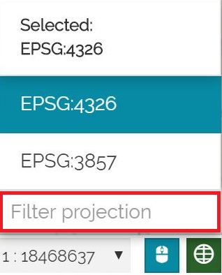
MapStore also allows the user to change the map's Coordinate Reference System. To do so, simply click on the current CRS displayed in the footer.
A selector will appear, allowing you to choose from the available systems as shown below:
It is also possible to Zoom to the maximum extent of the current projection by clicking the  button.
To customize the list of projections available in the CRS tool dropdown menu, click the  button to open the Available Projections panel.
In this panel, the user can:
-
Use the search bar to quickly locate a specific projection within the list of available systems
-
Toggle the checkboxes to choose which projections will be visible in the CRS tool dropdown list
-
Select the default projection for the map by clicking the
 button; once selected, the icon will change to
  to indicate the current default setting.
Warning
The list of available CRSs depends on the CRS Selector configuration.
Note
If the map viewer mode is set to 3D Navigation the user can view the Camera Position in the Footer. By clicking the  button, the user can access the following options:

-
View the camera coordinates (
Lat,Lng, andAlt), which update dynamically as the camera position changes in the viewer -
Select the available CRS
-
Select the available Height options
Warning
The Camera Position tool is not enabled by default in MapStore. However, it can be configured within application contexts if needed.
Note
MapStore can be configured to connect to a GeoServer endpoint exposing thousands of standard CRS definitions. This enables users to search for the desired CRS and its definition dynamically by fetching ti from GeoServer instead of manually defining it and so without redeploying the application or editing configuration files. This capability is disabled by default and requires additional configuration of the CRS plugin. For details on how to enable it, refer to the online plugin documentation.